
Cozumel Island
DEMOGRAPHIC CHARACTERISTICS
7. Population.
7.1. Population by gender.
7.3. Localities of the municipality of Cozumel.
7.4. Housing.
7.5. Economic Characteristics.
7.6. Main sectors of activity.
7.7. Protected Natural Areas (PNAs).
7.7.1. Federal PNAs:
I. Cozumel Reefs National Park (CRNP).
II. Northern Portion and Eastern Coastal Strip Flora and Fauna Protection Area, Terrestrial and Marine of Cozumel Island (NPECS).
III. Mexican Caribbean Biosphere Reserve.
IV. Cenote Aerolito Flora and Fauna Protection Area.
7.7.2. State Natural Protected Areas:
V. Laguna Colombia State Natural Refuge for Flora and Fauna.
VI. Chankanaab Lagoon Natural Park.
VII. Cozumel Jungles and Wetlands (State Reserve).
7.7.3. International Designations:
VIII. UNESCO Man and the Biosphere Programme (MaB-UNESCO) Reserve.
7.7.4. RAMSAR Sites:
IX. Cozumel Reef National Park.
X. Mangroves and Wetlands of the Northern Cozumel Island.
8. Diagnosis of water resources and associated elements in the basin.
8.1. Current Situation of Water Resources.
8.2. Drinking Water, Sewerage, and Sanitation.
8.3. Hotel Infrastructure.
7. Population.
1) Resident Population.
The resident population refers to the population living within the island. To estimate this value, the population counted in the INEGI Population Census according to the 2020 Population and Housing Census is considered.
2) Floating Population.
Following the definition used by CONAPO, the floating population is "those who travel from one place to another and are at a given location, regardless of how long they have been living there, but whose habitual residence is not that location." (Chávez & Corona, 2006)
This phenomenon of population mobility has implications on the demand for goods and services and on the generation of waste, which is considered the population burden. To analyze the floating population, two main modalities are distinguished:
a) Migration (especially temporary migration)
b) Daily or routine mobility; further subdivided according to the reasons or activities that originate the mobility:
1.- For consumption activities. Activities related to:
Consumption of services, such as education or health.
Consumption of goods, including food, clothing, and others, including those derived from trips for social reasons, where the purpose is to visit friends and family, for example.
2.- For production activities. Considered for work-related reasons.
In the case of Cozumel, the island's tourist vocation generates dynamics of temporary migration and daily mobility. As an example of temporary migration, it is common for citizens from abroad (to mention the most common countries, Canada and the United States of America) to visit for weeks or months to spend certain seasons in tourist sites or cities conducive to relaxation. Among the two cases of daily mobility, in the case of consumption motive, we can mention visits from residents from the rest of the state of Quintana Roo, such as the closest example being residents of Playa del Carmen city, who visit the island for a day trip. The same journey could apply to people who, due to a productive activity, visit the island daily for work.
Below are the visitor data to the island for the years 2021 and 2022. Visitors are differentiated according to the mode of transportation used, being the three possible modes of access: by air through the Cozumel International Airport, by sea through ferry or Ferry, from Playa del Carmen city, or from an international cruise ship.
TABLE 1.- Floating population or visitors to the island
|
Visitors |
% |
2021 |
% |
2022 |
|
Cruise ship visitors |
42.4 |
522,697 |
79.9 |
3,378,261 |
|
Air passengers |
43.2 |
531,678 |
15.7 |
663,261 |
|
Ferry passengers (entries) |
14.4 |
177,019 |
4.4 |
185,065 |
|
Total Visitors |
100 |
1,231,331 |
100 |
4,226,596 |
Official statistics are insufficient for the purposes of this Management Program since they do not include the number of daily visitors from Playa del Carmen to Cozumel, which reached 1,865,565 passengers in 2022 according to the APIQROO portal. These visitors use public services such as drinking water and drainage, visit (and saturate) the most relevant tourist sites in the destination (such as El Cielo). They are users of municipal infrastructure, and the government has not considered them for decision-making, such as allocations of state and federal budgets to the municipality - so it will never have the resources to manage the impacts of these very high visits.
7.1. Population by gender.
Based on data from the 2020 INEGI Population and Housing Census, of the total inhabitants of the municipality, 50.1% are male (44,402 men) while 49.9% are female (44,224 women).
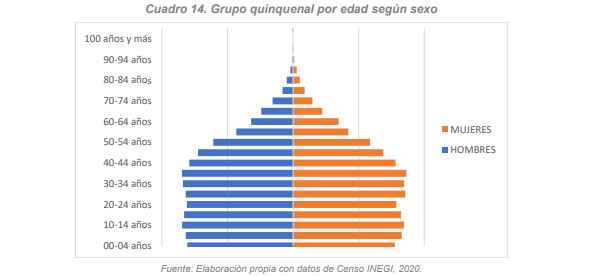
7.2. Population density.
The area of the municipality of Cozumel is 488 km2, in this territory, in 2020, the number of 31,078 households was counted, of which 26,424 (85.02%) are registered as inhabited households. The population density of Cozumel in 2020 was 181.6 inhabitants/km2
7.3. Localities of the municipality of Cozumel.
Of the 88,626 inhabitants counted in 2020 in the municipality, 84,519 (95.36%) live in the municipal seat of Cozumel, that is, in the island portion. Therefore, references to indicators or data corresponding to the locality or city of Cozumel may be shown as representative of the municipality.
7.4. Housing.
In the 2020 Population and Housing Census, 31,078 households were counted, of which 26,413 (84.99%) are registered as inhabited households.
Below are the main population and housing indicators with data from the INEGI census, 2020.
Total population 88,626 100 %
Female population 44,224 49.9 %
Male population 44,402 50.1 %
Population aged 0 to 14 years 22,157 25 %
Population aged 15 to 64 years 62,038 70 %
Population aged 65 years and over 4,431 5 %
Total households 31,078 100 %
Total inhabited households 26,413 85 %
7.5.- Economic Characteristics.
Tourism is the predominant economic activity on the island, which belongs to the tertiary sector. According to the INEGI Directory of Companies and Establishments in its 2019 update, 94.3% of economic units belong to activities related to commerce and services. 5.6% corresponds to activities of the secondary sector, and only 0.1% of the registry of economic units refers to activities of the primary sector.
In Cozumel Island, tourism represents the main economic activity. Classified as a sun and beach destination, Cozumel offers a great diversity of attractions and activities of various kinds. It is classified as one of the most popular places in the world for diving and water activities. It is part of the largest coral reef system in America.
The natural beauties, the hospitality of its people, and the safety of the destination have made Cozumel one of the favorite destinations for tourists in the Riviera Maya. Today it is a leading cruise port in Mexico and Central America, and according to APIQROO data, the average from 2010 to 2022 is 3,029,266 people per year. In 13 years, almost 40 million people have visited Cozumel, making cruise tourism the main source of income for the municipality.
7.6. Main sectors of activity.
- Primary sector.
On the island, tomatoes, lemons, habanero peppers, spearmint, and other products are cultivated. Fruit trees are also utilized in family orchards. As for livestock, cattle breeding is carried out on a total of 32 private ranches, which have an approximate inventory of 300 heads of cattle and 500 horses. Fishing is distributed among 3 cooperatives and a large independent sector of fishermen who supply the population and the tourist industry; one of the cooperatives also develops alternative tourism (tertiary sector), and another of them already industrializes lobster for commercialization. (SECTUR, Universidad de Quintana Roo, 2013) Only 3 fishing companies and two agricultural fumigation companies are registered in the DENUE.
- Secondary sector.
Among the activities of the secondary sector are: Mining, generation, transmission, and distribution of electricity, water supply, and gas, construction, and manufacturing industries.
On the mainland, the CALICA Company (now Sac-Tun) is located, where stone materials, mainly limestone, are extracted. Its production is estimated at 6 million tons, destined entirely for export to the United States. Additionally, there are some small industries for construction materials, mechanical workshops, and tortilla factories. (Universidad de Quintana Roo, SECTUR, 2013)
CALICA's mining activity (now Sac-Tun) reports more than 251 employed persons. On the island, there are two other mining companies, with a total employed staff of no more than 40 people. The collection, treatment, and supply of water belong to the public sector, and the employed staff does not exceed 60 employees. There are 19 companies related to construction.
The production of various foods amounts to 110 registered companies, with 10 dedicated to water purification and bottling. Regarding the production and manufacture of textiles, clothing, and accessories, 28 economic units are counted. There are 79 workshops dedicated to the manufacture of various products, mainly to supply the construction industry, sixteen various printing houses, and 19 workshops or industries dedicated to the manufacture of various products.
- Tertiary sector.
The tertiary sector comprises trade and services activities. Tourist trade is considered important on the island, including the offer of imported items and handicrafts. Some imported items advertise tax advantages. There are department stores, public markets, private stores, and official sector stores for the consumption of products on the island.
Among the tourist services offered in Cozumel, hotel establishments, food and beverage establishments, travel agencies, bank branches, tourist transportation services, car, motorcycle, and bicycle rentals, tour operators, etc., stand out. (Universidad de Quintana Roo, SECTUR, 2013)
There are 2,786 economic units in Cozumel that offer products or services, the majority of which are directly or indirectly related to the demand for tourist activities.
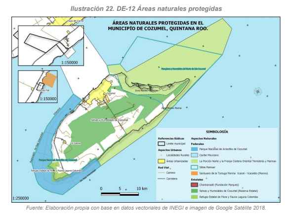
7.7. Protected Natural Areas (PNAs).
Cozumel Island is surrounded by four federal Protected Natural Areas (PNAs), and it also has three state Protected Natural Areas, being considered a Biosphere Reserve under the Man and the Biosphere (MaB) program by UNESCO. Below, each of its natural areas is detailed.
7.7.1. Federal PNAs:
I. Cozumel Reefs National Park (CRNP).
On the southern coast of Cozumel Island lies the Cozumel Reefs National Park (CRNP), designated as a Protected Natural Area in the Official Federal Gazette on July 19, 1996, covering an area of 11,987.87 hectares. The CRNP encompasses the entire Federal Maritime Land Zone (which corresponds to the interior portion of the Federal polygon).
The park protects significant coral reefs due to their biological diversity, which has served as the basis for promoting a significant international diving tourism industry. The most important reef areas include Paraíso, Cedral, Dzul-Ha, Chankanaab, San Francisco, Palancar, Colombia, and Maracaibo.
The purpose of the National Park is to conserve the natural environment to ensure the balance and continuity of ecological processes, safeguarding the genetic diversity of existing species, ensuring the rational use of resources, as well as providing a conducive environment for educational and recreational activities, scientific research, and the study of the ecosystem and its balance.
The National Park is considered one of the most important diving sites in the world; its coral reefs are part of the Mesoamerican Barrier Reef System.
II. Northern Portion and Eastern Coastal Strip Flora and Fauna Protection Area, Terrestrial and Marine of Cozumel Island (NPECS).
The Flora and Fauna Protection Area of the northern portion and the eastern coastal strip, terrestrial and marine of Cozumel Island, was established by Federal Decree published in the Official Federal Gazette on September 25, 2012. It is located on the island of the municipality of Cozumel, Quintana Roo state, with a total area of 37,829.17 hectares. Notable within the Flora and Fauna Protection Area is the diversity of terrestrial and marine ecosystems that develop there and the diversity of species that inhabit it. It has a Management Program that constitutes a planning and regulation instrument based on knowledge of the problems of the area, its natural resources, and their use within the area. This document proposes the organization, prioritization, and coordination of actions that will allow achieving the objectives of creating the Protected Natural Area (PNA).
It is worth mentioning that the mangroves and wetlands of the Northern Cozumel Island are Ramsar sites (February 2, 2009), which are habitats for a large number of endemic species and harbor threatened or endangered species such as: Caretta caretta, Ctenosaura similis, Chelonia mydas, Eretmochelys imbricata, among others.
The site is home to some species of birds seasonally, such as the flamingo (Phoenicopterus ruber) and the white-crowned pigeon (Columba leucocephala). It has species of mangroves subject to special protection such as Rhizophora mangle, Avicennia germinans, Laguncularia racemosa, and Conocarpus erecta, which represent a natural barrier protecting the coast from the onslaught of waves and climatic phenomena, reducing the damage inland. The main land uses on the site are: conservation, research, and sustainable use, also including public use. The ecosystems and biodiversity of this PNA face various threats, derived from natural phenomena and human activities carried out in the Influence Zone of the PNA. Among them are pollution and deterioration of the water quality of the aquifer, pollution from solid waste, presence of introduced species (rats and house mice, feral dogs and cats, casuarinas), illegal fishing, among others.
III. Mexican Caribbean Biosphere Reserve.
This is a recently created protected natural area. The decree was published in the Official Federal Gazette on December 7, 2016, and was announced within the framework of COP13 on Biodiversity, held in Mexico in December of the same year.
It is located east of the Yucatán Peninsula and has five marine ecoregions called the Southern Gulf of Mexico Shelf, Mesoamerican Caribbean Shelf, Mesoamerican Caribbean Slope, Yucatan Basin, and Cayman Mountain Range.
It is located in the municipalities of Isla Mujeres, Benito Juárez, Tulum, and off the coasts of Puerto Morelos, Solidaridad, Cozumel, Bacalar, and Othón P. Blanco, in the state of Quintana Roo, with a total area of 5,754,055.36 hectares.
The Mexican Caribbean is characterized by its diverse habitats: in the terrestrial environment, there are tropical forests, such as medium semi-deciduous forests, medium sub-deciduous forests, and low sub-deciduous forests. In the coastal environment, there are coastal dunes, sandy beaches, and coastal lagoons with vegetation such as flooded grasslands, "petenes," and mangroves.
It hosts 50% of the Mesoamerican Barrier Reef System (SAM), which is the world's first and only transboundary reef barrier.
In the marine environment, seagrass beds and coral reefs predominate, with all habitats containing species of conservation significance such as, sea turtles, sharks, rays, and fish associated with coral reefs, among others.
This reserve records approximately 1,900 species of terrestrial and marine flora and fauna, around 86 species of coral, more than 500 species of fish, 140 of them associated with coral reefs, among others.
With the declaration of this Protected Natural Area (PNA), the conservation of lagoons, wetlands, and the most important turtle nesting beaches in the state will be achieved.
IV. Cenote Aerolito Flora and Fauna Protection Area.
It is the most recently created federally protected natural area, with a decree published in the Official Gazette of the Federation on August 15, 2023. It covers an area of 10.21 hectares, located on the west-central coast of Cozumel Island. This area contains coastal wetlands that represent transitional ecotones between terrestrial and aquatic elements, where water is the main factor controlling the environment and associated biodiversity.
Cenote Aerolito is one of the 18 cenotes registered on Cozumel Island and, due to its low elevation above sea level and its associated cave and cavern systems, it is completely flooded. It is one of the two cenotes on the island with a direct connection to the Caribbean Sea through a 240-meter underwater cave. This connection determines its anchialine character, characterized by an underground zone of encounter and interaction between fresh continental waters and salty marine waters, as well as salinity gradients in its conduits, known as haloclines. Its interconnectivity and underground water flows with the Caribbean Sea make ecological and biological processes unique. Additionally, due to the constant exchange of organic matter, nutrients, and species with external ecosystems, it is considered a natural laboratory where evolutionary processes of marine-origin organisms are observed. These organisms, which at some point entered the cave system and found optimal conditions for development, eventually evolved and separated from their ancestors to become new species adapted to the particular conditions of the ecosystem.
A total of 293 native species have been recorded in this system, including 60 vascular plants, 70 invertebrates, one tunicate, and 162 vertebrates. Of these, 27 are endemic, and 25 are listed in some category of risk in the NOM-059-SEMARNAT 2010. Cenote Aerolito is considered one of the most biodiverse anchialine cave ecosystems in the world, with around 100 species of invertebrates, representing 60% of Mexico's anchialine fauna. It hosts an unusual abundance of sponges, echinoderms, and annelids, making it the anchialine cave with the highest richness of echinoderms worldwide. It also harbors invertebrates that only inhabit this cenote, such as the demosponge (Amphibleptula aaktun), the cavernous starfish (Copidaster cavernicola), the brittle star (Ophionereis commutabilis), the amphipod (Cymadusa herrerae), and the isopod (Cirolana adriani).
7.7.2 State Natural Protected Areas:
V. Laguna Colombia State Natural Refuge for Flora and Fauna.
On July 15, 1996, the Decree declaring the region known as Laguna Colombia a protected natural area was published in the Official Gazette of the State Government of Quintana Roo, with the category of Zone Subject to Ecological Conservation, State Refuge for Flora and Fauna, covering a total area of 734.59 hectares, entirely located on Cozumel Island in the municipality of Cozumel.
On August 10, 1999, the Decree modifying the surface of the Zone Subject to Ecological Conservation, State Refuge for Flora and Fauna, Laguna Colombia was published in the Official Gazette of the State Government of Quintana Roo, increasing its surface from 734.59 hectares to 1,113.64 hectares, with a perimeter of 19,405.60 meters, all located on Cozumel Island in the municipality of Cozumel.
On August 17, 1999, the Decree establishing the Management Program of the protected natural area with the category of Zone Subject to Ecological Conservation, State Refuge for Flora and Fauna Laguna Colombia was published in the Official Gazette of the State Government, which in the evaluation component contemplates the need for the Management Program to be evaluated, reviewed, and, if necessary, adjusted to the biological, social, and economic conditions of the region every three to five years.
The decree modifying the similar one declaring the region known as Laguna Colombia a protected natural area, with the category of zone subject to ecological conservation, state refuge for flora and fauna, located in the municipality of Cozumel, Quintana Roo state.
On June 29, 2001, the Decree approving the Law of Ecological Balance and Environmental Protection of the State of Quintana Roo was published in the Official Gazette of the State Government, establishing the types and characteristics of state-competent Protected Natural Areas. Additionally, in the fourth transitory article, it establishes that the category of protected natural area corresponding to areas or zones established prior to the entry into force of the Law will be determined. However, on April 7, 2011, the decree establishing the modification similar to the one declaring the region known as Laguna Colombia a protected natural area, with the category of zone subject to ecological conservation, state refuge for flora and fauna.
Within Cozumel Island, the Laguna Colombia area contains the greatest variety of ecosystems of high ecological value: coastal lagoons, marine bars, and rocky coasts. Currently, within the Flora and Fauna Refuge of Laguna Colombia, the Punta Sur Ecological Reserve is located, which operates as a Natural Park.
The transitory articles of the decree establish that in the future, the protected natural area, the region known as Laguna Colombia, with the category of zone subject to ecological conservation, state refuge for flora and fauna, should be understood as a State Ecological Park.
VI. Chankanaab Lagoon Natural Park.
On the western coast of the island lies another protected natural area, Chankanaab Lagoon, currently safeguarded by the Protected Natural Area of Chankanaab Lagoon National Park, which was declared a refuge zone for the protection of flora and fauna, being one of the most natural and spectacular sites on Cozumel Island. The name "Chankanaab" derives from Mayan and means: small (chan) sea (kanaab). It has a saltwater lagoon that originally was a natural aquarium, with a multitude of fish species and abundant underwater flora, where the islanders used to bathe.
The decree creating the Chankanaab lagoon natural park on Cozumel Island, municipality of Cozumel, state of Quintana Roo, was published in the Official Gazette on September 26, 1983. The Chankanaab area is considered a natural asset with its wooded, botanical garden, maritime, aquatic, recreational, and service areas, representing the Caribbean and considered by locals and strangers alike for its beauty, unique in America.
It is of interest to the Federal, State, and Municipal Governments of Cozumel that a Natural Park be created to protect this area, preserving and developing the ecologically attractive reserves and natural value, providing the current and future human community with spaces adapted to develop recreational, educational, and cultural activities. It is relevant to mention that the Chankanaab Lagoon Natural Park covers an area of 13.65 hectares, including the Federal Maritime Terrestrial Zone and is located as part of and southwest of the
The State Government, through the mentioned Decree, gratuitously transfers the use and destiny of an area of 92.31 hectares belonging to the legal fund of Cozumel, for the creation of the "Chankanaab Lagoon" Natural Park that will be managed by the "Trust" exclusively for the creation of the mentioned Park and Natural Aquarium, likewise, the works carried out by it and its destination rights over the Federal zone and Federal works built there; declaring it unattachable, inalienable, imprescriptible, and non-transferable; reverting the ownership at all times to the State of Quintana Roo.
Among the immediate objectives are:
- To integrate it into the community of Cozumel Island according to the national park system, serving as a fundamental factor for the improvement and well-being of its inhabitants and the state.
- To achieve, through the organization and coordinated efforts of the community, federal, state, and municipal governments, that the operation of Chankanaab Park be self-financing.
The medium-term objectives are:
- To protect this area by preserving and developing ecologically attractive reserves and natural value, providing the current and future human community with spaces adapted to develop recreational, ecological research, educational, and cultural activities.
- To promote socio-cultural tourism, so that the people of Mexico know this region of their country and appreciate what it represents.
- To instill in students a sense of respect for nature and a desire for scientific research.
VII. Cozumel Jungles and Wetlands (State Reserve).
On April 1, 2011, the decree of the natural protected area with the category of state reserve called Cozumel Jungles and Wetlands was published in the official state gazette, located in the municipality of Cozumel, Quintana Roo, with an area of 19,846.45 hectares; which is considered an ecosystemically relevant region, as it is a mosaic of habitats that includes low deciduous jungles, medium subdeciduous jungles, mangroves, tasistals, and coastal dune vegetation.
The inland jungles of Cozumel Island, Quintana Roo, mostly well-preserved, facilitate water infiltration into the subsoil, the only source of supply to the wells of the Potable Water and Sewerage Commission (CAPA).
The administration, conservation, development, and preservation of ecosystems and their elements in the Natural Protected Area, with the category of State Reserve, Jungles and Wetlands of Cozumel, are the responsibility of the Secretary of Urban Development and Environment of the State of Quintana Roo (SEMA).
In turn, article four establishes that the Secretary of Urban Development and Environment, and Amigos de Sian Ka'an A.C., based on the Collaboration Agreement signed by both entities and with the support of the Municipality of Cozumel and in coordination with the National Commission of Protected Natural Areas (CONANP), will formulate the corresponding Management Program, being able to invite other Federal, State, and Municipal Public Administration Dependencies and Entities, civil associations, research centers, and higher education institutions to participate in its preparation and in the fulfillment of its objectives.
Article eight states that any public or private project that intends to be carried out within the protected natural area, or in its area of influence, must have the authorization of the State Government and the Municipality of Cozumel and must be consistent with the guidelines, compatibilities, uses, and criteria established in the Local Ecological Zoning Program of the Municipality of Cozumel, Quintana Roo, and other provisions established by the corresponding Management Program, which in no way will contravene, modify, or restrict the provisions contained in the aforementioned Local Ecological Zoning Program, allowing the transfer and concentration of uses and exploitation within the same Environmental Management Unit on the same terms provided by the Local Ecological Zoning Program of the Municipality of Cozumel.
Cozumel is the world's leading cruise destination and has great potential for developing ecotourism and bird watching activities, promoting the diversification of the island's tourist offer in particular and of Quintana Roo in general.
7.7.3. International Designations.
VIII. UNESCO Man and the Biosphere Programme (MaB-UNESCO) Reserve.
Biosphere reserves are areas composed of terrestrial, marine, and coastal ecosystems, recognized by UNESCO's Man and the Biosphere Programme. In each of them, solutions are promoted to reconcile biodiversity conservation with sustainable use, economic development, research, and education.
Furthermore, they constitute "sites supporting science for sustainability", meaning they are specially designated areas aimed at assessing interdisciplinary approaches to understand and manage changes and interactions of social and ecological systems, including conflict prevention and biodiversity management. Biosphere reserves consist of three interrelated zones that fulfill three interconnected, complementary functions, and mutually reinforce each other:
- The core area, composed of a strictly protected ecosystem, contributes to the conservation of landscapes, ecosystems, species, and genetic variations. A biosphere reserve may have one or more legally established core areas where research and other low-impact activities are permitted.
- The buffer zone, surrounding or adjacent to the core area, where activities compatible with sound ecological practices are conducted, contributing to research, monitoring, training, and scientific education. Activities such as environmental education, recreation, ecotourism, and applied and basic research can take place in this zone.
- The transition zone is the belt of the reserve where a greater number of activities are authorized to promote sustainable economic and human development from social, cultural, and ecological perspectives. It is considered a multiple-use zone, where activities such as sustainable resource utilization, such as agriculture, can be carried out. Biosphere reserves fulfill three complementary functions: Conservation, development, and logistic support.
The conservation function is aimed at protecting genetic resources, species, ecosystems, and landscapes.
The development function aims to promote sustainable economic and human growth from sociocultural and ecological perspectives. In this context, various productive activities can be carried out, subject to current national regulations, to ensure and strengthen the three pillars of sustainable development: social, economic, and environmental protection.
The logistic support function aims to promote research, environmental education, training, and monitoring activities related to local, national, and global conservation and sustainable development issues.
7.7.4. RAMSAR Sites.
IX. Cozumel Reef National Park.
Cozumel Reef National Park is home to hundreds of species from all kingdoms, including notable corals (hard and soft), zoanthids, and hydrozoans, as well as sponges, crustaceans, mollusks, echinoderms, and reef fish. Plant communities are represented by algae, of which there is a huge variety, as well as seagrasses.
Cyanobacteria are of great ecological relevance, and like many microorganisms, they are very abundant in this ecosystem. The area is a reservoir of marine flora and fauna species, some of which are threatened, endangered, or subject to special protection. This includes marine turtles (green, loggerhead, and hawksbill), lobster, queen conch (Aliger gigas), black coral (Antipathes sp.), black coral (Antipathes lenta), and the corals Acropora palmata and Acropora cervicornis, among others exploited for their high intrinsic value of natural substances, such as the octocoral (Plexaura homomalla).
To meet Ramsar site criteria, 11 technical criteria were met, among which the following stand out:
Criterion 1: Cozumel Reef National Park is part of the world's second-largest barrier reef, the Mesoamerican Barrier Reef, which extends off the coasts of Belize, Honduras, Guatemala, and Mexico (Quintana Roo).
Criterion 2: 13 species of fauna reported for the site were found to have some category or status of protection according to the Official Mexican Standard-059-ECOL-2001 (DOF, 2002). 10 species registered as subject to special protection, 5 species as threatened, and 6 species as endangered.
Within the Ramsar site, the ownership regime of the Park is entirely federal, as it covers the maritime portion and the federal maritime land zone; however, other ownership regimes are present in the neighboring area. In the surrounding area, ownership regimes include ejidal, private, federal (covering the federal maritime land zone), and municipal, with private ownership predominating.
X. Mangroves and Wetlands of the Northern Cozumel Island.
The boundary of the Ramsar site coincides on its terrestrial portion with that established in the decree of the Federal Protected Natural Area called the Isla Cozumel Flora and Fauna Protection Area (APFFC). Unlike the ANP decree, this Ramsar site does not incorporate oceanic wetland areas, such as the micro-atolls off the eastern coast and other strictly marine systems, and is limited only to the northern and eastern coastlines of Cozumel Island, including its coastal lagoons.
The Ramsar site is located in the northern region of the insular part of the municipality of Cozumel, in the state of Quintana Roo. This state, located in southeastern Mexico, on the Yucatan Peninsula, covers an area of 50,425 km2 (according to INEGI's GIS) and its coastline extends along the Mexican Caribbean, making it the only state with access to this sea.
The Ramsar site encompasses nearly all the island's ecosystems (seagrass beds, mangroves, coastal lagoons, jungles, tasistales-saibales, halophytic vegetation, and coastal dunes), so its protection will allow for the preservation of representative examples of Cozumel's natural richness.
In Cozumel, the protection of a significant portion of this ecosystem has a triple value: 1) It protects this type of jungle, which is almost non-existent in the rest of the state, 2) There are no other PNAs on the island that include considerable extensions of this vegetation, and 3) These communities are where a good portion of the island's endemism is concentrated.
There are 13 criteria considered for its designation as a Ramsar site, among which the following stand out:
- The geological characteristics of the island, formed mainly by different limestone rocks that confer great porosity and permeability to the subsoil, favor the rapid infiltration of rainwater into the aquifer. Although it is shallow and extensive, it allows for the existence of some cenotes, coastal lagoons, and freshwater and brackish dolines, which are crucial for the development of the varied local flora and fauna, as well as for the human communities present on the island. This karstic aspect of Cozumel is extremely important regionally since it is the only island in the Caribbean portion of Mexico with such a groundwater system.
- This criterion is considered for the endemism present in the site, which is very high in Cozumel. Arriaga et al., 2000, and Holsinger, 1992, cite 4 species of endemic invertebrates: Agostocaris bozanici, Bahadzia setodactylus, Janicea antiguensis, and Yagerocaris cozumel. However, in recent years, other species exclusive to anchialine systems have been added, such as sponges Calix maya, Haliclona stygobia, Haliclona chankanaabiis, Neosiphonia microtriaeneae, Svenzea germanyanezi, Diplastrella cozumella (Gómez & Calderón Gutiérrez 2020), and Amphibleptula aaktun (Gómez et al., 2022), starfish Copidaster cavernicola, Asterinides sp., and Ophionereis commutabilis (Solís-Marín and Laguarda-Figueras 2010; Bribiesca-Contreras et al., 2019); crustaceans: Xibalbanus cozumelensis (Olesen et al., 20217); Procaris mexicana (von Sternberg & Shotte 2004), Anchialocaris paulini, and Agostocaris zabaletai (Mejía-Ortíz, Yañez, and López-Mejia 2017). The ichthyofauna is represented by 3 endemics: Poecilia velifera is endemic to the Yucatan Peninsula, specifically to the coastal cenotes of northern Quintana Roo; Cyprinodon artifrons is also endemic to the peninsula, and its distribution in Quintana Roo is along the peninsular coastal strip and in the inland lagoons of Cozumel and Isla Mujeres; Floridichthys polyommus is the third endemic species of the peninsula, found in all three states. It is common in coastal lagoons with mangroves and Thalassia sp. seagrass beds in shallow and brackish waters.
- Finally, it is emphasized that the terrestrial zone, as well as the maritime surroundings beyond the limits of the PNAs or Ramsar mentioned, have a close interrelation; therefore, it must be considered when developing guidelines and planning works or activities. For more information on protected natural areas, consult the respective management program, such as the PNAC whose extensive management program version is available on the CONANP platform at the address https://simec.conanp.gob.mx/pdf_libro_pm/30_libro_pm.pdf
And the summary at https://simec.conanp.gob.mx
8. Diagnosis of water resources and associated elements in the basin.
8.1. Current Situation of Water Resources.
Availability Zones, Surface Water, and Groundwater. According to CONAGUA in the Hydrological Administrative Region XII Yucatan Peninsula (RHA XII PY), groundwater is the main source of freshwater supply and a fundamental part, along with precipitation, in agricultural practices. Additionally, it supports the development of the main user sectors such as public-urban, multiple, service, and industrial, among others.
For the four aquifers in the region: Cerros y Valles, Isla Cozumel, Xpujil, and Yucatan Peninsula, the average annual recharge is 25,316 hm3 per year. Based on the Official Gazette of the Federation (17/09/2020), the average annual groundwater availabilities published for the four hydrogeological units are 4,965 hm3. The Yucatan Peninsula unit has the highest availability, with 4,657 hm3 per year.
According to Lesser, H., Azpeitia, J., & Lesser, J. (1978). Geohydrology of Cozumel Island, Quintana Roo. Hydraulic Resources, 7(1), 32–49, recommended extraction volumes in the well zone should be 1.3 million cubic meters annually with the possibility of extracting an additional volume of 1 million cubic meters annually under the recommendations of exploiting only in the designated area, controlling drawdowns, and using a special device for water extraction.
The Quintana Roo Basin (32A) includes Cozumel, Mujeres, and Contoy islands, which account for 31% of the state's surface. As is the case in almost the entire peninsula, there are no surface currents due to high infiltration in the terrain and scarce relief; some lagoons, such as Cobá, Punta Laguna, and La Unión; which form along the coast, Conil, Chakmochuk, and Nichupté, as well as water holes.
According to CONAGUA data, both surface and groundwater have an average renewable water volume of 1741 hm³/year. On the other hand, the renewable water per capita in 2019 was 993 m³/person/year, a figure expected to decrease to 780 m³/person/year by 2030 according to CONAPO population projections.
According to CONAGUA information from the Public Registry of Water Rights (REPDA) as of December 30, 2022, the volume granted in the state of Quintana Roo is 985,230 m3/year of surface water and 1,250,000,411. m3/year of groundwater for a total of 1,250,985,641. m3/year, with the main user being the service sector, followed by agriculture and urban public.
For the case of the municipality of Cozumel, the total volume granted, with current data as of December 30, 2022, was 23,000,468. m3/year of groundwater.
WATER USES AND CONCESSIONED AND ASSIGNED VOLUMES IN COZUMEL
No. Titles USE Volume of extraction of national waters (m3/year)
132 AGRICULTURE 31,420.00
5 DIFFERENT USES 53,914.00
3 DOMESTIC 609.50
13 INDUSTRIAL 3,766,717.00
1 LIVESTOCK 500.00
2 URBAN PUBLIC 8,325,504.00
47 SERVICES 10,821,804.30
203 TOTAL 23,000,468.80
In Cozumel, there are 203 titles in the REPDA and the highest granted volume is destined for the service sector (47.05%), followed by the urban public sector (36.20%), and then the industrial sector (16.38%), these being the three most representative uses on Cozumel Island.
8.2. Drinking Water, Sewerage, and Sanitation.
The potable water supply system of the island consists of 132 wells for potable water extraction, with a production capacity of 136 liters per second (lps). There are three asbestos-cement conveyance lines of 8", 12", and 14", of which the first two are out of service and only the 14" line remains in operation. The water extracted from the production area is distributed through two pumping stations "Base 4" and "Base 1" and a distribution network of 163,195 linear meters, 24 hours a day through 20 sectors.
In Cozumel, there are also identified growth areas where there is no service coverage, many of them considered irregular.
According to CONAGUA in the Manual of Drinking Water, Sewerage, and Sanitation, per capita water consumption for inhabitants in warm climates varies according to socioeconomic class, for residential it is 400 l/person/day, for the middle class it is 230 l/person/day, and for the popular class it is 185 l/person/day. According to data from the State Water and Sewerage Commission (CAPA), potable water and sanitary sewerage coverage in Cozumel from 2018 to 2022 have remained stable; in 2022, potable water coverage is estimated at 70.06% and sanitary sewerage at 69.64%.
There is a registry of 20,048 users, with the domestic sector being the most representative with 17,062 connections (85%), followed by commercial with 2,626 connections (13%), these being the sectors where the highest collection is recorded.
Cozumel has a sanitary sewerage coverage of 69.64%. The sanitary sewerage system consists of 12 pressure lift stations, which are interconnected, and pumping is carried out to convey wastewater to the "San Miguelito" treatment plant with an installed capacity of 220 lps. The operating sanitary sewerage network is around 104 km. of pipes of different diameters.
Recently, CAPA has started the rehabilitation of the wastewater collection system on Rafael E. Melgar Boulevard, replacing 1,704 m of collector with 30" diameter HDPE pipe and replacing 1,748 m of potable water line with diameters of 3", 6", and 12".
8.3. Hotel Infrastructure.
The hotel infrastructure of Quintana Roo is also one of the best in the country. According to tourism indicators provided by SEDETUR, from January to December 2022, there were 127,399 rooms and 1,331 hotels. In 2021, there were 1,200 hotels, growing by 10.9% in 2022, and there were 118,772 rooms, growing by 7.3%, respectively. In Cozumel, as of December 2022, there were 4,922 rooms in 73 hotels.