Cozumel Island
PHYSICAL CHARACTERISTICS
1. Location and Biophysical Description.
1.1. Physiography.
1.2. Geomorphology.
1.3. Geology.
1.4. Edaphology.
1.5. Soil Type and Use.
1.6. Hydrology.
2. Climate.
3. Hydrology.
4. Caves and Caverns.
1. Location and Biophysical Description of the basin.
Cozumel is a Mexican island located in the Caribbean Sea and is considered the third largest and the second most populated island in the country. It extends approximately 48 km from north to south and 14.8 km from east to west. The island lies about 19 km off the mainland coast and approximately 62 km south of Cancún. Together with the continental enclaves of Calica and Xel-Há, it constitutes one of the eleven municipalities of the State of Quintana Roo. Its administrative seat and largest urban center is the city of San Miguel de Cozumel.
The Municipality of Cozumel covers an area of 48,808.11 hectares, of which only 2.49% corresponds to mainland territory, while 97.50% comprises Cozumel Island itself. The island is located approximately 17.5 km offshore from Playa del Carmen, northeast of the Yucatán Peninsula. Its extreme geographic coordinates are: 20°36' N and 20°16' N latitude, and 86°44' W and 87°20' W longitude, making it the easternmost territory of Mexico — a feature symbolized in the municipal coat of arms by a rising sun on the horizon. The municipality borders the Caribbean Sea to the east and shares maritime boundaries to the north and south with the Municipality of Solidaridad, as well as western limits facing the mainland of Solidaridad.
On March 19, 2016, Cozumel was incorporated by UNESCO into the World Network of Biosphere Reserves. This designation includes both terrestrial and marine environments. The island is predominantly flat and composed of limestone derived from coral reef formations. Its highest natural elevation is less than 16 meters above sea level.
Cenotes formed through the long-term filtration of water through limestone formations can be explored through activities such as swimming, snorkeling, and cave diving, allowing observation of diverse aquatic and marine species. The location of the main population center is considered strategically important within the regional urban system, as it functions as one of the principal nodes in the urban network of the State of Quintana Roo and serves as a regional integration center.
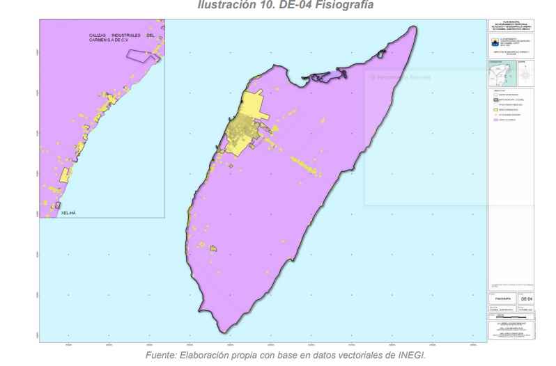
1.1. Physiography.
According to the Municipal Program for Territorial, Ecological, and Urban Development Planning of Cozumel, the municipality is entirely located within the Yucatecan Karst Physiographic Province, covering 48,808.11 hectares (100% of the municipal territory). Within this province, two subprovinces are identified: the Yucatecan Karst, occupying 48,725.14 hectares (99.83%), and the Lower Coast of Quintana Roo, covering 82.97 hectares (0.17%).
Cenotes and sinkholes generally present limited surface openings; however, the associated cave systems may extend horizontally over considerable distances.
The landform system is classified as follows: rocky plains with rocky or cemented surfaces covering 47,299.94 hectares (96.91%); rocky plains with consolidated substrate covering 1,064.02 hectares (2.18%); areas classified as not applicable totaling 361.18 hectares (0.74%); and beach or coastal bar formations with rocky or cemented substrate covering 82.97 hectares (0.17%).
The island likely originated from geological detachment along the eastern margin of the Yucatán Peninsula during the formation of the Yucatán Basin, between the Late Mesozoic and Early Cenozoic eras. Its karstic topography promotes rapid rainwater infiltration, which over geological time has caused the collapse of cave roofs, forming rocky depressions known as sinkholes or cenotes.
In Cozumel, both cenotes and sinkholes are generally small in size. Near Punta Sur, several of these features occur within the jungle immediately north of Colombia Lagoon, along with a small limestone plateau at Punta Celarain.
The karstic nature of the island prevents the formation of permanent surface rivers, as rainfall infiltrates through fractures and fissures into the groundwater system. Consequently, surface runoff toward the sea carries virtually no suspended sediments.
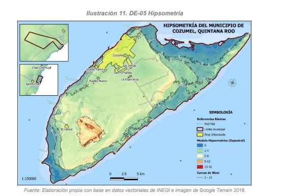
1.2. Geomorphology.
The geomorphology of Cozumel Island is represented in a single landform, which is the denudational karstic relief, karstic plain with incipient dolinization processes (39,789.3733 ha) (84.0766%), and three types of coasts are distinguished.
The flood and/or intertidal coast, located in the northern and southern areas of the island, are characterized by the presence of lagoon areas that have a direct connection to the sea, thus having a permanent dynamic of ebb and flow of tides. It covers an area of 4,740.1335 ha (10.0161%).
The biogenic coral reef coast is mainly located on the eastern coast of the island in two sites, on the central coast from Mezcalitos to Chen Río and on the northern coast covering the Reefs and the Royal Castle. On the western coast of the island, it occurs from La Caleta, La Ceiba, Dzul-Ha, and part of the Curvas de Tormentos area. It covers an area of 985.148 ha (2.0817%).
The undifferentiated coast with the beach is present on the eastern coast of the island on the southern coast from Chen Río to Playa Box and on the northern coast from Mezcalitos to the reefs. It covers an area of 1,810.4735 ha (3.8256%).
The land relief on Cozumel Island has evolved in the dynamics of the geographical cycle through a series of constructive and destructive processes that are permanently affected by the force mainly of the tides on its coasts and its trade winds, as well as the weathering it receives from different factors such as rainfall and, at times, from meteorological phenomena called tropical storms and hurricanes, which act as a balancer of the unevenness; that is, it causes elevated areas to tend to fall and fill the depressed areas. These processes cause the relief to go through different stages.
The relief is affected by both biotic and abiotic factors, of which those properly geographic are considered abiotic factors of exogenous origin, such as relief, soil, climate, and bodies of water.
The climate with its elements such as pressure, temperature, and winds. Surface water with the action of runoff, river, and marine action. Tides modifying the coastline. They are factors that aid in modeling, favoring erosive processes.
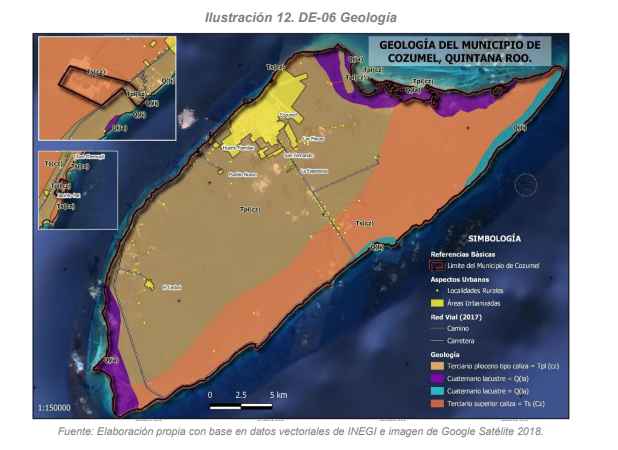
1.3. Geology.
The geological units identified on Cozumel Island are described as follows:
The Quaternary lacustrine system (Qla) is located in the southern portion of the island, extending from Palancar to Punta Celarain and comprising mangrove and coastal lagoon environments. In the northern sector, this formation is also present, extending from Isla de la Pasión to Aguada Grande. This unit covers an area of approximately 2,832.61 hectares (5.98%).
The Quaternary littoral system (Qli) occurs along the eastern coastline, extending from Punta Morena to the Mezcalitos wetland areas, and also from Punta Arrecifes to Punta Molas. This geological unit covers approximately 1,242.93 hectares (2.61%).
The Tertiary Pliocene limestone formation (Tpl–cz) occupies the central portion of the island and extends toward the western coast, covering an area of 27,352.61 hectares (57.81%).
The Upper Tertiary limestone formation (Ts–cz) represents another major geological unit, covering approximately 15,893.80 hectares (33.58%) of the island’s surface.
The geology of Cozumel Island is consistent with that of the broader Yucatán Peninsula. Geological studies indicate that the region originated from marine sedimentation processes beginning in the Tertiary Period, deposited over a basement of rocks dating to the Secondary Era (Mesozoic). These deposits formed an extensive carbonate platform that gradually uplifted through intermittent phases of emergence and subsidence toward the end of the Cenozoic Era, a process that continues today in the northern sector of the peninsula.
This carbonate platform is primarily composed of granular, friable, whitish limestone locally known as sascab, a characteristic material widely distributed throughout the region.
Sedimentary rocks constitute the dominant lithology of the island, corresponding mainly to deposits from the Tertiary and Quaternary periods, both belonging to the Cenozoic Era (approximately the last 66 million years).
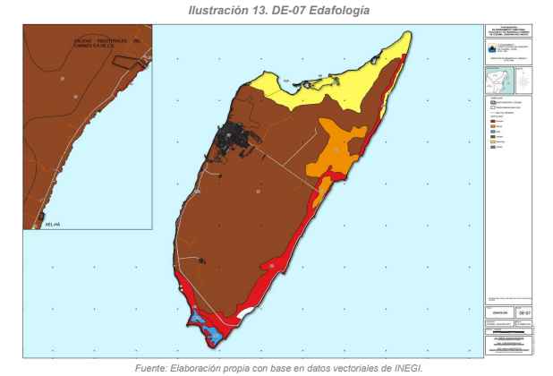
1.4. Edaphology.
Five principal soil groups are distributed across the surface of Cozumel Island, exhibiting markedly unequal spatial coverage.
The dominant soil type is Rendzina, currently classified as Leptosol (LP) according to the World Reference Base for Soil Resources (SICS–ISRIC–FAO, 1999). This soil covers approximately 33,404.99 hectares (70.59%) and is widely distributed throughout the central portion of the island. Leptosols are shallow soils limited in depth by continuous hard rock occurring within 10 cm of the soil surface, typically presenting an A–R profile. These soils commonly develop over limestone substrates and are associated with areas affected by strong erosion processes. Continued soil degradation may result in the complete loss of soil cover, exposing bedrock and leading to an advanced and often irreversible stage of land degradation.
The second most extensive soil group corresponds to Solonchaks (SC), covering approximately 5,702.83 hectares (12.05%) of the territory. These soils are primarily distributed in swampy and low-lying areas at the northern and southern ends of the island, as well as along portions of the northeastern coast. Orthic Solonchaks occur mainly in southern wetlands, while gleic variants are present in northern and northeastern sectors. Solonchak soils develop in coastal plains and marsh environments and are characterized by elevated salt concentrations and variable organic matter content.
The third soil group is Gleysol (GL), predominantly of the mollic subtype, covering approximately 2,892.87 hectares (6.11%) of the island’s surface. These soils are located mainly along the eastern coast, immediately north of the transversal highway. Gleysols are poorly drained soils in which groundwater remains permanently or seasonally close to the surface, typically within the upper 50 cm of the soil profile. The most common types in the area are humic and calcareous Gleysols, formed under conditions where relief and hydrology promote prolonged water stagnation.
The fourth soil group corresponds to Arenosols (AR), which occupy approximately 4,647.59 hectares (9.84%). These soils are characterized by sandy-loamy or coarser textures and exhibit minimal pedogenic development. They typically present an almost undifferentiated soil profile with a thin A horizon and very low organic matter content over loose, unconsolidated sandy material lacking structural cohesion. Arenosols are highly permeable and possess limited water retention capacity, often subjecting vegetation to water stress. Their high porosity promotes strong aeration, accelerating oxidation processes and rapid mineralization of organic matter.
A notable characteristic of Arenosols is their high susceptibility to erosion, particularly wind erosion, when not stabilized by adequate vegetation cover, as observed in mobile dune systems present in certain coastal areas of the island.
Finally, Hortisols (ZU) represent anthropogenic soils modified for agricultural use and favorable for crop production. These soils occupy approximately 671.88 hectares (1.40%) of the territory.
1.5. Soil Type and Use.
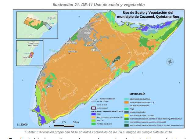
According to the vector dataset on land use and vegetation from INEGI Series VI, the Subperennial Medium Forest constitutes the dominant vegetation type within the municipality, covering 34,239.63 hectares (70.15% of the total municipal area).
The next most extensive land-cover categories are mangrove ecosystems, occupying 4,753.15 hectares (9.74%); urbanized or built-up areas, covering 3,104.40 hectares (6.18%); and secondary arboreal vegetation derived from Subperennial Medium Forest, which extends over 1,860.54 hectares (3.81%).
The remaining 7.61% of the municipal territory consists of a mosaic of additional land uses and vegetation types, including cultivated grasslands, water bodies, tular wetlands, areas lacking apparent vegetation cover, low deciduous forest, coastal dune vegetation, secondary shrub mangrove vegetation, and secondary shrub vegetation associated with Subperennial Medium Forest
According to information from INEGI Series IV, agricultural activities occur primarily in small rural settlements and ranches, where maize is cultivated on a limited scale (planted area of approximately 17 hectares reported in 2009). Commonly cultivated fruit tree species include soursop (Annona muricata), avocado (Persea americana), nanche (Byrsonima crassifolia), papaya (Carica papaya), coconut (Cocos nucifera), guava (Psidium guajava), tamarind (Tamarindus indica), guaya (Talisia olivaeformis), banana (Musa paradisiaca), among others. However, several of these ranches have been abandoned or discontinued due to legal and land-tenure issues. Likewise, livestock activities formerly located in the northwestern sector of the island have declined significantly.
Of the total municipal area of 48,808.11 hectares, approximately 3,605 hectares correspond to UGA CP1, an Environmental Management Unit designated for urban development, representing 7.4% of the municipality’s territory. The polygon known as the Fundo Legal defines the official boundary of the population center, within which approximately 74% of the area is currently urbanized.
Within the total urban footprint, approximately 68% of human settlements are located inside the Fundo Legal limits, while 31% occur outside the formally established population center boundaries. The largest of these external areas corresponds to the AGEB that includes the Cozumel International Airport.
In addition, built infrastructure — primarily associated with hotel developments — is distributed along the northern coastline. Toward the island’s interior, clusters of buildings are also present, most of them corresponding to residential uses within irregular or non-planned settlements. Overall, the urbanized area is estimated at 2,399.70 hectares, representing approximately 4.92% of the island’s total surface area.
2. Climate.
The climate is classified as A w, (f) iw", hot humid rainy tropical with intense summer rains (Téllez et al. 1989). The annual precipitation is 1,607 mm (the month with the least precipitation is March with 44.1 mm and the month with the most precipitation is September with 241.6 mm). The average annual temperature is 25.5°C (the hottest months are July and August with 27.3°C and the coldest month is January with 22.9°C; García 1988). In Cozumel Island, hurricanes and so-called "nortes" are frequent factors, as they can be devastating, but also their rains help recharge the aquifer. Cozumel is exposed to this type of phenomenon because it is within the cyclonic trajectory zone of the Caribbean Sea (INE-SEMARNAP 1998).
The most recent hurricanes that hit Cozumel are Gilberto (1988), Roxana (1995), and Emily (2005), with Gilberto being especially devastating.
3. Hydrology
Groundwater
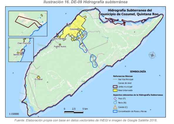
Due to the geological characteristics of Cozumel Island, nearly the entire subsurface forms part of a continuous aquifer system. Groundwater is primarily contained within the Chankanaab and Abrigo geological formations, which function as a single hydrogeological unit where water circulates readily through highly porous carbonate strata. The aquifer consists of a freshwater lens that, due to its lower density, floats above underlying saline water, forming a typical coastal karst aquifer system. Consequently, most of the island can be classified as an unconfined phreatic aquifer (Lesser, 1978; CAPA, 2002).
The aquifer extends over approximately 288 km², representing about 60% of the island’s total surface area. The greatest thickness occurs along groundwater capture axes 2 and 3, located north of the transversal highway. The central region of the island constitutes the principal recharge zone, where infiltration rates and freshwater storage are highest. From this area, groundwater flows radially through the subsurface toward the coastline until discharging into the sea.
As a result, flood-prone and wetland areas are supplied both by direct rainfall infiltration and by groundwater discharge moving toward coastal zones, where freshwater eventually mixes with marine waters under tidal influence.
The northern lagoon system, together with the Laguna Colombia area, forms one of the largest floodable zones on the island, although smaller temporary ponds also occur in other sectors.
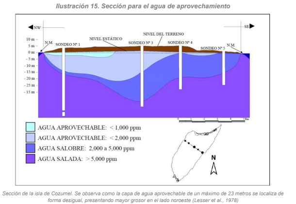
Regarding the hydrogeochemical structure of the aquifer, the freshwater–saltwater interface is generally located at depths between 15 and 23 meters in the central portion of the island. Toward the coastline, however, the thickness of the freshwater lens decreases significantly, and groundwater salinity increases, with total dissolved solids (TDS) exceeding 2.5 g/L in shallow zones. Under these conditions, groundwater in coastal areas is unsuitable for human consumption without prior desalination treatment.
For this reason, groundwater extraction wells are primarily located in the central sector of the island, slightly toward the northwest, where the freshwater lens is thicker and total dissolved solids concentrations remain within acceptable limits for potable use.
There are no significant perennial or intermittent rivers or surface streams on Cozumel Island. This condition is primarily due to the highly karstic nature of the terrain and the thin soil layer, which promotes rapid infiltration of rainfall into the subsurface.
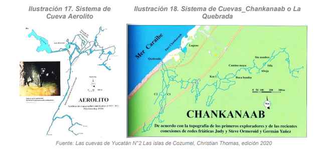
This hydrogeological setting favors extensive underground hydraulic circulation, resulting in the development of a widespread system of cavities and caverns throughout the island. Some of these formations reach the surface, forming features locally known as sinkholes or cenotes. A representative example is the La Quebrada cave system, located at the southern end of Chankanaab Natural Park, which has been explored for approximately three kilometers using scuba-diving techniques.
The island’s aquifer can be conceptualized in cross-section as a relatively horizontal freshwater lens underlying the island and floating above seawater. The thickness of this lens decreases toward the coastal margins and reaches its greatest development in the central portion of the island, where it may attain an approximate thickness of up to five meters.
The central zone of the island constitutes the primary area of rainfall infiltration and percolation into the aquifer. Between freshwater and seawater lies a transition zone known as the saline interface, where salinity increases with depth. In karst aquifers such as that of Cozumel Island, this interface is typically sharp, with a transition thickness generally not exceeding two meters.
Despite the efficient natural drainage resulting from high infiltration capacity across most of the island, lagoon systems occur in certain coastal areas where clay-rich sediments and exposed bedrock locally reduce infiltration rates. Many of these lagoons are temporary and may disappear during periods of seasonal drought. Others remain permanent due to their proximity to the coastline and continuous interaction with groundwater and marine influence. Representative examples include Laguna Colombia, Laguna Ciega, and Laguna de Montecristo.
4. Caves and Caverns.
The Yucatán Peninsula possesses a remarkable diversity of subterranean geomorphological formations, many of which are difficult to access. Francisco Solís Marín, a researcher at the Institute of Marine Sciences and Limnology of the National Autonomous University of Mexico (UNAM), has conducted studies on organisms inhabiting anchialine cave systems on Cozumel Island in the Mexican Caribbean. According to his research, the fauna associated with these environments is highly specialized and biologically unique. Organisms living within these caves have adapted to obtain energy from microbial mats that develop on cave walls and ceilings. One notable example is the cave-dwelling starfish Copidaster cavernicola, discovered by speleologist Germán Yáñez in the cave known as “El Aerolito,” located on the western side of Cozumel Island.
In Cozumel, approximately 180 subsurface entrances have been documented. About 50% of these contain water or are completely flooded, while others remain entirely dry, including flank-margin caves associated with the paleodune formations surrounding the island. These environments support high levels of biodiversity, characterized by strong ecological specialization and adaptive strategies that enable species to survive under extreme environmental conditions. A significant proportion of the recorded species are endemic.
Recent research has identified endemic species of microcrustaceans inhabiting flooded cave systems on the island. Interestingly, their closest related species have been reported in distant regions of the world, underscoring both the evolutionary significance and ecological sensitivity of these subterranean ecosystems. Consequently, the conservation of these environments is essential, not only for the protection of existing species but also because of their broader ecological importance to the island’s environmental integrity.